The legendary 'Weather Tom' offers us his latest meteorological insights.
04.10.2017
Finish Line - WEATHER SNAPSHOT (High Confidence)
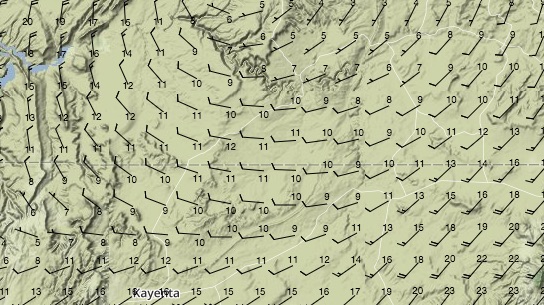
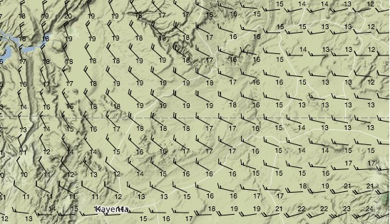
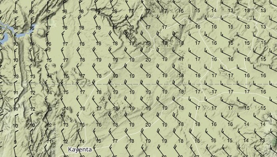
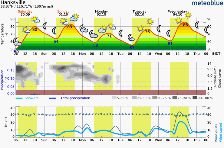
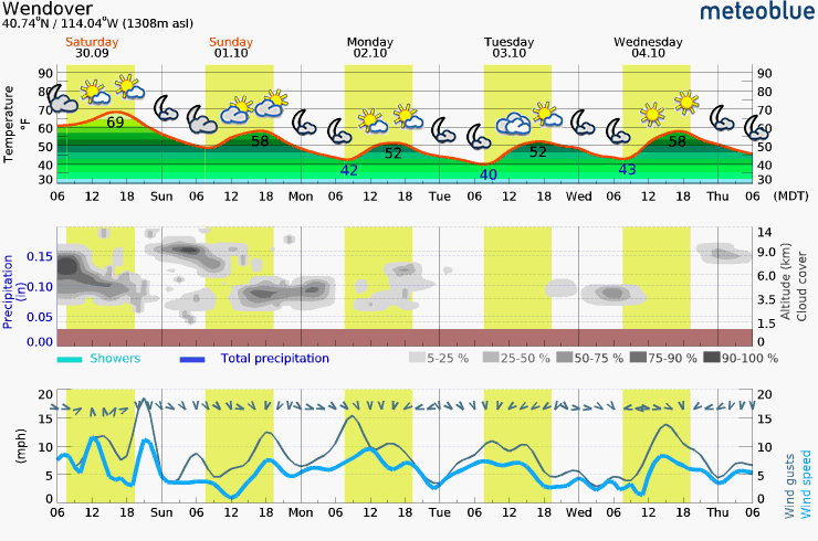
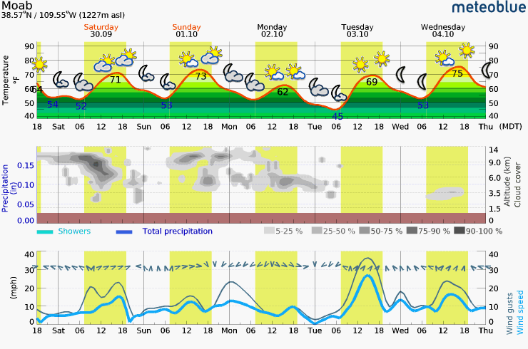
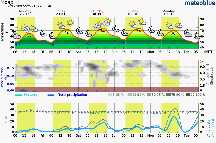
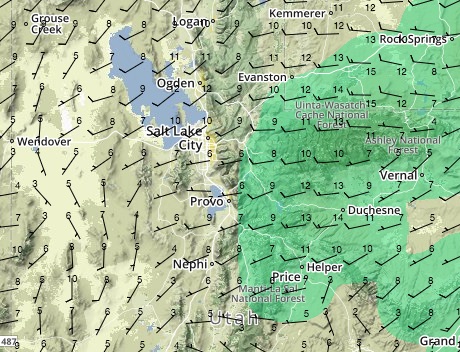
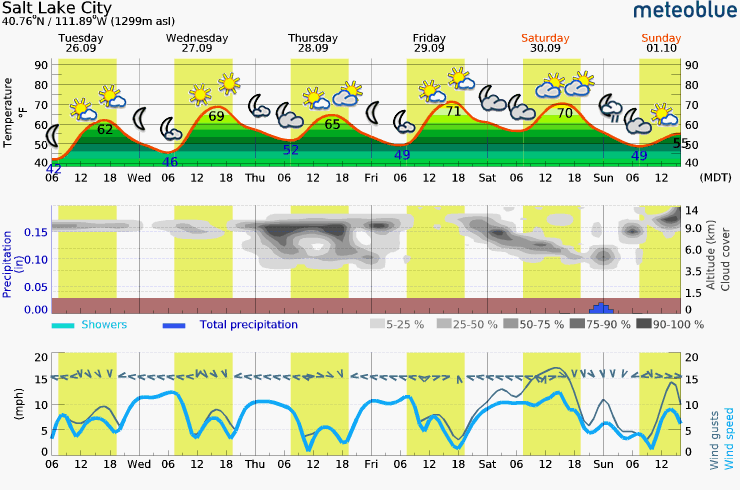
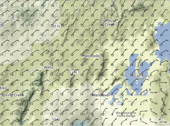
The end of the Icarus Trophy is looking like it will be more celebrating the end of an epic adventure than flying on Wednesday. There is a slight chance of morning flights around the finish area however it is likely that it will blow out very quickly.
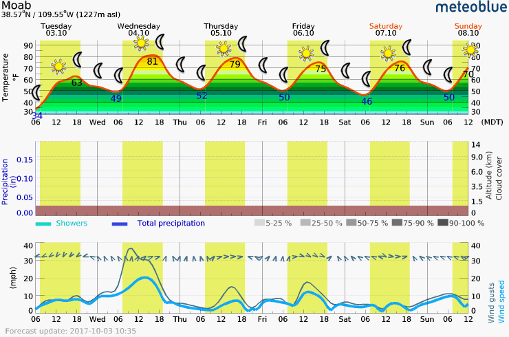

Overall, there is a much tighter pressure gradient of the area for Wednesday, which will cause winds gusting over 30mph in the afternoon. Temperatures will be unseasonably warm after days of cooler temps than average. Abundant sunshine will make the day great for hanging out re-capping the stories of this amazing event. If flying does occur, early on the winds will be from the SE at 10mph but later veer to South. By noon, it appear that the veering trend continues and winds will shift to SW and intensify quickly.
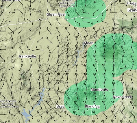
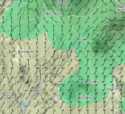
03.10.2017
Day 10 - WEATHER SNAPSHOT (High Confidence)
The end of the Icarus Trophy looks to be shaping up nicely with almost certainly the nicest weather pilots will have seen over the last week on Tuesday. Wednesday will be abundantly sunny but there is a good chance winds will become strong after noon. If it is possible to arrive in time to fly for at least a portion of the day or evening Tuesday, it would make sense to push and get there – you will not be disappointed.

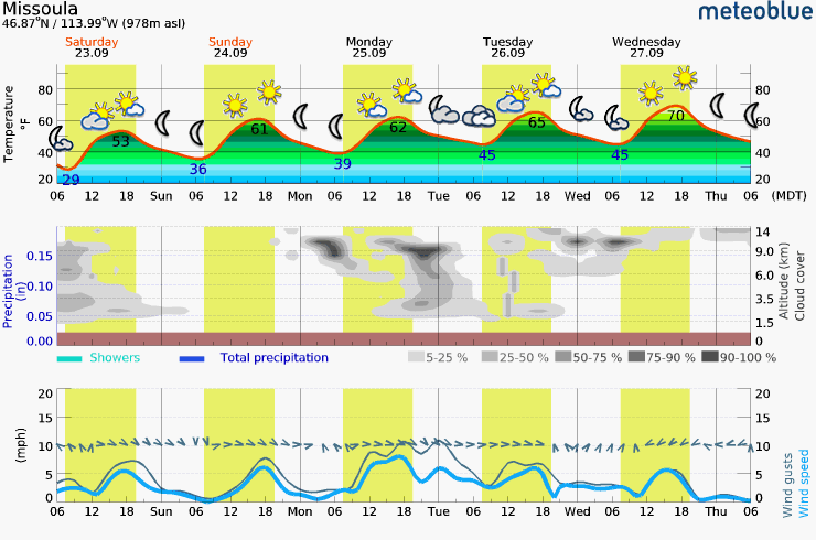
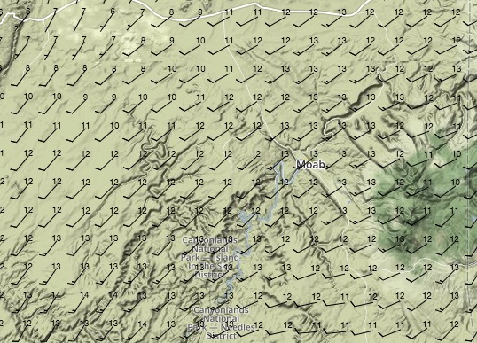
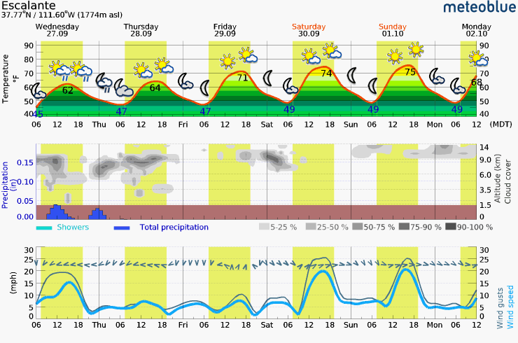
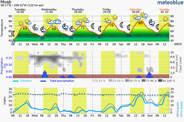
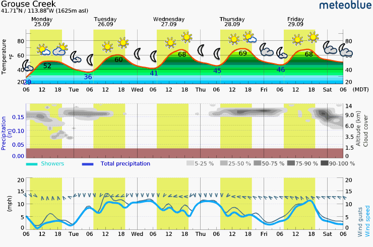
Monday - Saturday Meteogram (Moab, UT)
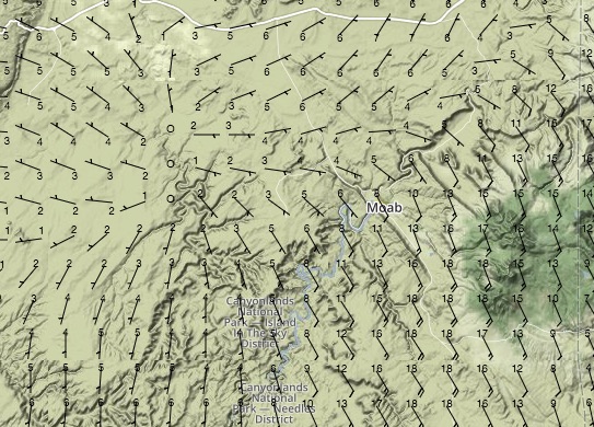
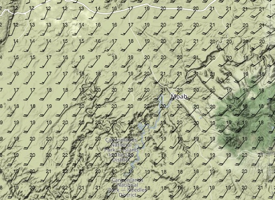
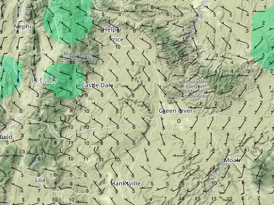
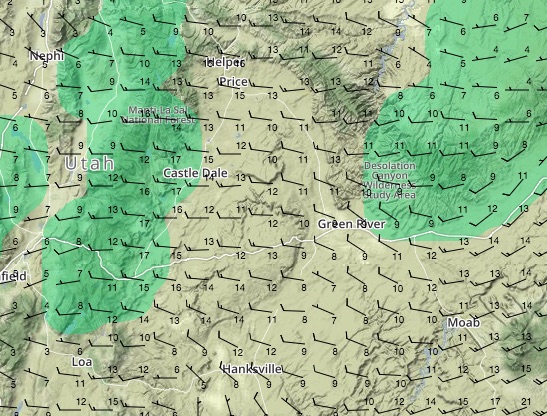
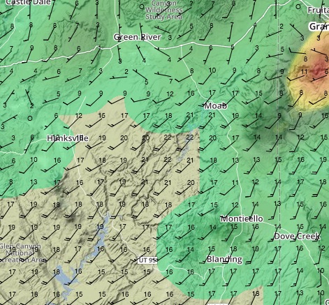
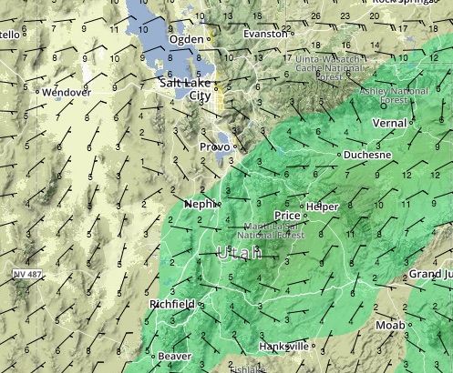
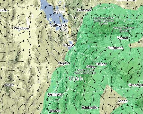
Moab Area Winds Forecast
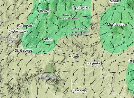
There is a break between fronts at the moment that is going to make Tuesday pretty glorious over the greater Moab area, to include the route from Hanksville, for most of the day. The wind will be light, 5-8mph, from the North over Hanksville and North East over Moab, early on. As the day progresses, winds will remain light over the entire forecast area from the Northeast. Aloft, it ramps up quickly over 8k so flow low.

Looking ahead to Wednesday, it appears that there will be a decent chance of flying for a portion of the day but the weather will be fantastic for celebrating your accomplishments over the past 10 days or so. Some models do indicate another light day but my sense, given the driving dynamics, is that it will not be flyable all day for everyone – fingers crossed I am wrong. Having been around Moab, I can’t think of many better places to reflect on how lucky we are to be safe and enjoying such a grand adventure. Given the recent tragedy in Vegas, let’s keep safe and focused on just how fortunate we are.
02.10.2017
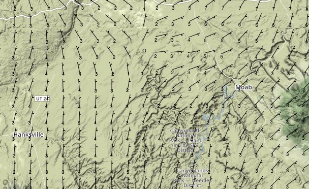
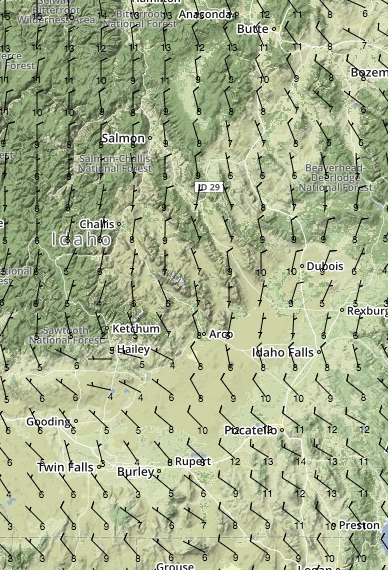
Day 9 - WEATHER SNAPSHOT (Low then High Confidence)
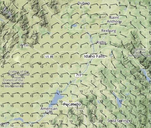
For the Red Dawn area, wake up EARLY and take a look at the winds. Though clear skies will dominate, there is massive model disagreement for the early morning hours on winds. It is likely that there will be a short window below 6500ft to fly in relatively manageable winds from North of West just as the sun comes up. All models are in violent agreement that at some point in later morning it will blow out and get progressively worse for most of the day.

Sunday - Thursday Meteogram (Red Dawn Area)
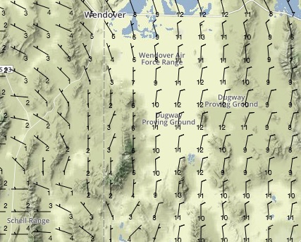
The series of cold fronts that have blown through the race course have made a mess of the dynamics controlling the weather. Forecast confidence is low in the morning as there is massive model variability early on but there are plenty of indicators that at sunrise it will be flyable for at least 4 hours or so. Red Dawn will be a game of watch and go but I am confident that whether it is foot dragging or ridge soaring, there will be some early morning excitement to be found.
Red Dawn Winds Forecast

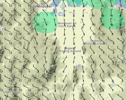
Looking ahead, Tuesday and Wednesday both look like they will be back to more normal conditions. On Tuesday it is likely that there will be an East tailwind between 5 and 10mph as the day progresses. Wednesday will have variable winds over the course and will probably be the most manageable day there has been in a while.
Thanks Tom, now we go live to Hank for the sports bulletin.
01.10.2017
Day 8 - WEATHER SNAPSHOT (Medium Confindence)
For the Adventure crew, Sunday will be a good day to progress toward Mesquite once any lingering showers dissipate. There will be an afternoon convergence line that runs North and South, which will be marked by a prominent cumulus line with some associated turbulence. The Race class will have a nice window in the morning with light West winds but as the day progresses the winds will increase. It is unlikely that the entire day will be usable by Canyon, Jack and, now, Tucker.
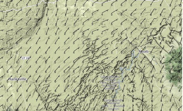
Adventure Crew Winds Forecast
The adventure class tomorrow will have a decent opportunity to make progress along the course. Early on, it is likely that there will still be some lingering showers from Saturday but that should clear out shortly after sunrise. Be observant for gusty winds on the surface but once in the air there will be a very welcome tailwind for most of the morning from the North at 5-10kts. After noon, a quartering tail wind, either from the NW or NE depending on which side of the convergence you fly, will continue to speed progress toward goal. Do not underestimate the potential for turbulence associated with the convergence should it materialize – particularly since it will be just prior to peak heating over the desert.

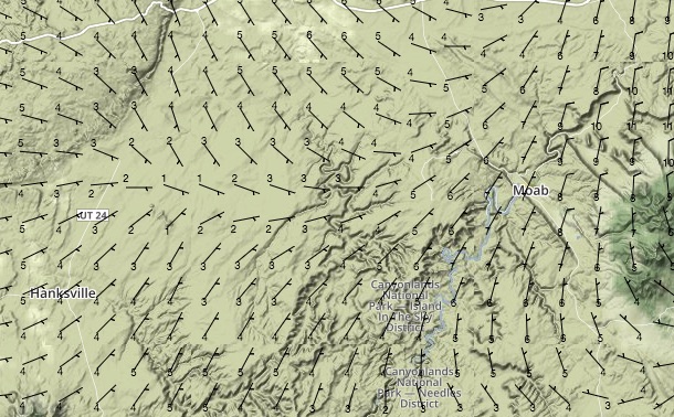
Race Group Winds Forecast
Jack, Canyon and Tucker will be able to make good progress on Sunday as well. The course area between Green River, Moab and Hanksville should be flyable for most of the day under the influence of WNW winds. Once further south toward Escalante, the winds will build rapidly from the West and reach 20kts after about 1400. Winds will also intensify as you progress west of Hanksville. Scenic flights around the various landmarks within the Green River, Moab, Hanksville triangle should be a safe bet but do not fly higher than necessary since winds above 7500 will begin to approach 15-17kts by 1100.

Looking ahead, Monday looks very favorable for big distances along the UT-NV border with a North tailwind all day long and not much change of precipitation. On Tuesday, the winds will again be North but much stronger and it will rule out flying for some possibly by noon time. For the race class, both Monday and Tuesday look favorable with relatively light winds over much of the remainder of the courseline on Monday and then an East tailwind on Tuesday for much of the day. The tailwind will be more intense, up to 15kts along the UT border, depending on how far South you are.
30.09.2017
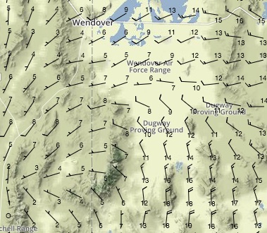
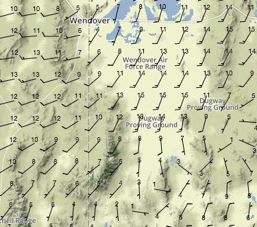
Day 7 - WEATHER SNAPSHOT (Medium Confidence)
Saturday is not shaping up as bad as it looked to be 24 hrs ago however the best possibility for progress will be in the morning and low to the ground. For both groups, favorable conditions should prevail early on at the surface and as long as you fly below 6,000ft, modest distances should be possible.
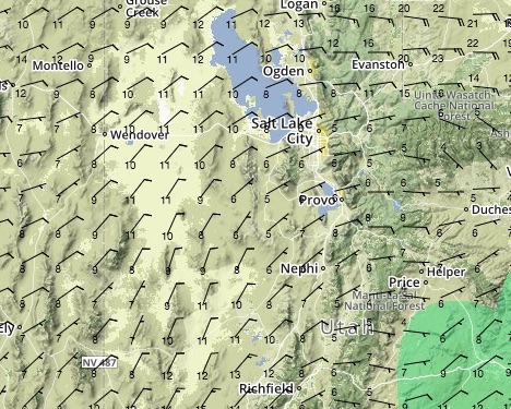
Western Gaggle Winds Forecast
The adventure pilots in West Wendover should enjoy calm morning conditions for take off and flying below the 7,000ft elevation. If you would like to make any distance, be in the air as early as you can to avoid the stronger winds, which will begin building late in the morning and continue to intensify as the day goes on. Early on expect in flight winds to be West at 6-10kts by mid morning and remain West building the 15-17kts by 16:00. Due to the cold front that will sweep across UT tomorrow, there is some chance of showers after 13:00. Once you begin to feel the winds are approaching your comfort level, it is sensible to land as they will not let up.
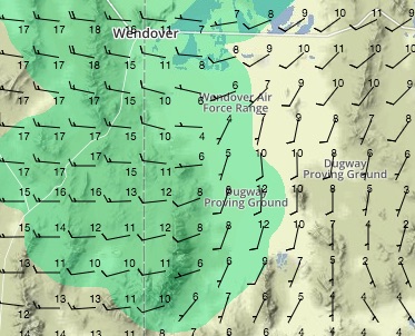
Jack and Canyon Winds Forecast
Jack and Canyon will have a good time flying locally early on in the morning with light surface winds out of the South and some incredibly scenic terrain. As the day progresses, the winds will remain manageable below 6,000ft as far south as Hanksville however once nearing that city, strong Southerly winds will prevail at 15-17kts. The most productive plan would be to fly locally in the morning and then try to make progress as far south as the winds will allow.
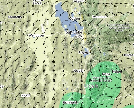
Looking ahead, Sunday’s conditions look favorable for the Western Gaggle making their way down toward the goal. There will be a comfortable quartering wind from the NW for most of the day on Sunday. To the East, progress will be slow along the Southern border of Utah with 15-20kt winds from the WSW. Prior to making it that far south, winds will be more manageable. Because the cold front is moving so fast, the forecast confidence in the later days is low at the moment.
29.09.2017
Day 6 -WEATHER SNAPSHOT (High Confidence)
Friday should be a great opportunity for all racers to make progress but it will be slowed by headwinds all morning and the possibility of afternoon thunderstorms remains over the race course. In the mountains East and South East of Salt Lake City, the unstable air will linger into the early morning of Friday but should not impact the take off time much if at all. For the adventure class, it should be a more straightforward day than Thursday was. It is very unlikely that much progress, if any at all, will be made on Saturday due to very high winds and some more potential for rain. Land where you want to spend Saturday at the end of the day Friday.
The weather all around the greater Salt Lake City area should be relatively favorable. From the start, there will be South winds at 5-8kts but there will be periods of higher gusts as the heating starts. Take off early if your desired end point at the end of the day requires it.
To the Southeast of the city, Canyon will want to start as early as the weather allows and make quick progress toward Moab because there will be widespread showers along the route starting around noon. There is a large degree of disagreement in the models over the extent of the moisture but they all indicate that it will grow worse after noon time. Jack’s best call is likely to cheat south along the race course en-route to Moab to minimize the possibility of showers or at least reduce their affect. Fortunately, by 11:00 or so the winds will start to veer and become more West which will with progress on the race course. By late in the afternoon there will be a very nice 10-12 kt push.
Along the adventure route, headwinds will determine the day. As fortunate as Tucker was with the winds almost bending to his will and providing a great push into an epic finish, now pilots will not be as lucky. As the day progresses that same veering pattern the racers will make great use of in the afternoon will slow the adventure class. Early on, the winds will be South and light but will build in the afternoon before becoming Southwest. Other than the ability to make more progress, there is not a compelling reason the start too early.
Friday Wind Forecast

Looking ahead, Saturday will be almost certainly be a wash on both courses due to the winds. These strong winds as well as some new precipitation will continue to impact the race course possibly through as late as Monday! The adventure division will likely find flyable conditions on Sunday by mid day – perhaps earlier – but progress is going to be very slow.
28.09.17
Day 5 -WEATHER SNAPSHOT (Medium Confidence)
According to John Paul Jones, ‘He who does not risk, can not win’. Tucker certainly took that to heart in Wednesday’s epic run. His reward for that boldness is that he will now be the first to experience the end of the weather from today as it exits to the NE. All racers will deal with some remnants from Wednesday’s precipitation but Thursday will not be a wash.. no pun intended.
Tucker’s Forecast
Up front, Tucker will deal with the lingering effects of the system that moved through the four corners area on Wednesday early in the morning. Once he is able to fly, he will see light winds and a primarily westward push to further aid his progress. As the day goes on, there is less possibility of being impacted by the showers that will be very widespread further north. Today was the crux of the flying up front and despite there being a slight possibility of more unfavorable weather closer to the Nevada border by Friday, it appears that it might not even matter.

Chase Group
The chase group will not be quite as fortunate. Showers will persist over a large portion of the day between Salt Lake City and Moab and affect the race course more than the adventure course. For Canyon and Jack, this does not mean they will be ground bound but the day will require patience and a close eye on the weather radar. Multiple short flight might be necessary to maximize distance on Thursday. Winds may be an issue for Canyon early in the day where 10-15kts over the hills will bring turbulence that will be enhanced by the instability from Wednesday’s system. By noon, however, the winds will back off and become light, 5-8kts, and shift from the East to the North East.
Further north, Lara and Dean will have no issues making progress along the courseline provided they are patient with the possibility of showers and bold enough to make a series of small flights until the weather pushes all the way through. Once the skies clear, they will have plenty of time to make progress along the course. Winds will be somewhat gusty in the morning for her and settle out the a manageable 8-10kts from the East later in the day. The primary concern would be turbulence and afternoon convection with all the remnant instability.

Looking ahead a few days, drier weather is back in the forecast for both the race course and the adventure course. It is almost certain that the worst of the weather is behind racers and as long and everyone can get their gear kinks worked out and keep making progress it should be a great few days coming up toward Vegas.
27.09.2017
Day 4 -WEATHER SNAPSHOT (High Confidence)
The first of several lows will begin to influence the race course in the near future – particularly South of SLC. Lara, Dean and Trey will have favorable conditions en-route to Pocatello and the greater Salt Lake area while Jack, Canyon and Tucker may have to deal with scattered showers, particularly in the afternoon. The typically stable mountain route that Canyon is flying may prove to be a great call. Nowhere on the course will it pay to race high due to strong winds aloft.

Northern Group
The chase gaggle will have another decent day of flying on Wednesday but the early morning downwind runs earlier in the week are going to be replaced by ENE winds early in the morning. Eventually, they will shift to a NE quartering wind as the day progresses. Fortunately it will still be fairly light, 5-10kts below 9kft but higher up the winds pick up quickly and above 10kft and flying high will be unpleasant most of the day. Lara will likely see widespread cloud cover in the morning; perhaps all three will.


Southern Group
The two lead groups, despite being on different routes, will both experience periods of showers on Wednesday which are a preview of later this week. This will alter their course lines but it is unlikely that these showers will ground racers for more than a short period. Historically, it has paid to be out in front and into the more stable weather south of Salt Lake but Tucker may not be as fortunate tomorrow. The predicted moisture and instability is being pulled up with a low pressure system tracking form California and he will be the first to see the impacts. He will also be bucking a head wind for much of the day. Jack and Canyon, on the other hand, will be have an Easterly crosswind which will bring turbulence near the mountains until they start to make their way further to the East at which point they will also be fighting that head wind. All that being said, Wednesday will overall still be a favorable day. At peak heating, the turbulence will be a factor for the racers in the south and extra respect should be paid to the bullet thermals releasing from some of the lower foothills.

Looking ahead a few days, the four corners area, to include much of the eastern extent of the race course, is going to become unfavorable. Those on that route will be grounded for a period of at least a day or two most likely, and considerable snow will fall in the higher elevation mountains. The adventure course will still fall prey to this unsettled weather however it will ground racers for a much shorter period.
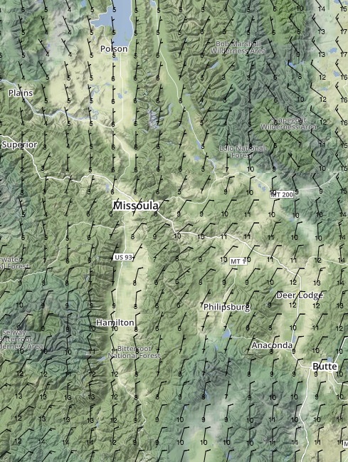
26.09.2017
Day 3 - WEATHER SNAPSHOT (Medium Confidence)
With the huge spread across the field some racers will enjoy a good day of racing weather on Tuesday while others might not. The leaders, particularly Tucker, will be rewarded with the best conditions and those at the back of the pack still in the Bitterroots and Beaverheads will deal with early morning moisture after a wet night.

Northern Group
The racers in the northern chase group will likely deal with some isolated rain showers early in the morning left over from Monday night. In the higher elevations snow on the peaks will emphasize the point that it is still unseasonably cool over the Bitterroots. Winds will be favorably from the North and similarly light to the previous two days. Afternoon thunderstorms and rain are nearly certain over both Northern ranges. Count on afternoon thunderstorms.
Central Group
The central group will also probably see some moisture in the morning but not as widespread as is the case deeper in the mountains to the North. Winds will be NNW and build from 5kts early on to 10-12kts in the afternoon. It is very likely that there will be afternoon thunderstorms.


Southern Group
The leaders will deal with slightly higher winds, up to 15kts, from the NW at 10kft but they will be lighter below 8kft and also if above 12kft. The greater Pocatello area should see clear skies over most of the day and the flats West of Salk Lake City will see some high clouds but nothing that will impact the race. The afternoon heating over the flats will increase turbulence and mid day will have the potential for exciting flying.
25.09.2017
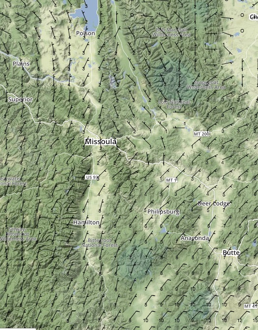
Day 2 - WEATHER SNAPSHOT (High Confidence)
Temperatures will return to a more seasonally normal standard for Monday and despite large patches of overcast across South Western Montana on Sunday afternoon, skies will be again clear and favorable for racing on day 2. Both the West and East gaggles will experience virtually the same weather but some instability will cause development in the mountains during the afternoon with local showers possible affecting the Western gaggle more.
Sunday night’s overcast will linger over some portions of Southern MT into the morning but should not affect racing. Monday and Tuesday will both be good race days but Wednesday is much less certain as a trough begins to influence the region. Much of what you will encounter depends on the progress you make Monday and Tuesday so push as far as possible – even if it means you should stop drinking early on in the evening.
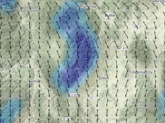
Winds aloft will again be light throughout the day. In the morning there will be a tailwind straight from the North that will build from 5kts at 10k early on to 10-12kts at that altitude by mid morning. As the racers still in the Bitteroots reach the end range, the winds will be from the West. Further East, the tailwind will dominate most of the day even when you encounter the flats at the end of the Beaverhead Range. An interesting point to note is that the winds are purely North above 13k and quite a bit stronger. If you are equipped with oxygen and have the balls to fly that high, you will make very quick progress as for most of the day the winds will hover around 20kts above 13k.
Looking ahead, there is some unsettled weather around Salt Lake City. The National Weather Service has winter weather advisories out warning of snow at higher elevations in the mountains. This widespread, unsettled weather may impact the race in a few days.
Here's the wonderfully nerdy stuff:
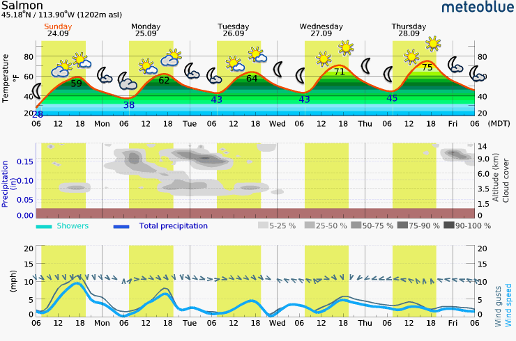
24.09.2017
Day 1 - RACE KICK-OFF WEATHER SNAPSHOT (High Confidence):
If any of the locals have a good memory, perhaps they will start growing weary of the race ushering in the first major frost/freeze warning of the year. The National Weather Service has issued the warnings all along the Bitterroot Valley covering most of the Northern portion of the race-course. The first few days look very promising for big distances if you can stand the temps for long periods at altitude. Dress warmly!
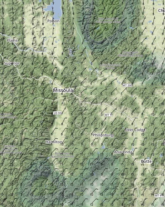
The lingering clouds and moisture will decrease overnight and the race will kick off under the influence of ridging which will be the dominant feature over the Bitterroot Valley through at least Tuesday. As the ridge builds, the conditions will grow increasingly favorable. On Sunday, the morning fog, if any around the lake, will burn off quickly and once in the air, a light tailwind will aid in progress toward Missoula.
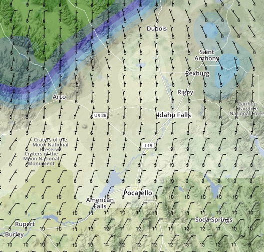
Winds aloft will be light throughout the day from the NNE all the way up to 14k. Expect 10kts or less up through that altitude. There is a very slight chance of building cloud cover nearing the Montana – Idaho border around the Idaho Falls area. Of course, the light and variable conditions are in the open areas of the valleys and the wind in the mountain passes will be considerably higher – particularly close to the ground.
Temperatures will be much lower than they have been over the last few days. The freezing level will hover around 7,000-7,500 ft but will dip by almost 1000ft during the afternoon. Thermal activity will follow the typical pattern but there isn’t much chance of overdevelopment because of the relatively high pressures. Thermal turbulence will be minimal but expect light mechanical turbulence on the South Side of all ridges and hills.
And now, some of that in glorious technicolour: